I spent almost a week in Kathmandu, in-between sight seeing, getting ready for my trek. I made trip after trip to the tourist ghetto of Thamel, searching for size 14 hiking boots (suprise success!), haggled endlessly over North Fake clothing, discovered secret sources of trail mix, and on the back burner discussed possible Tibet treks with travel agents. Finally, my pack full of much warmer clothing, I was ready.
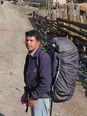

A couple of days before I was heading out, though, my intestines staged a revolt. Amy and I had an abortive trip to the medieval village of Bhaktapur thanks to my stomach, and the day before I left it wasn't much better. So, weak on antibiotics, I decided to get a porter/guide. Kumar came with me from Kathmandu, on the recommendation of my Tibet travel agent. He was quiet but nice, and full of stories about the mountains (some of which he swore me to secrecy).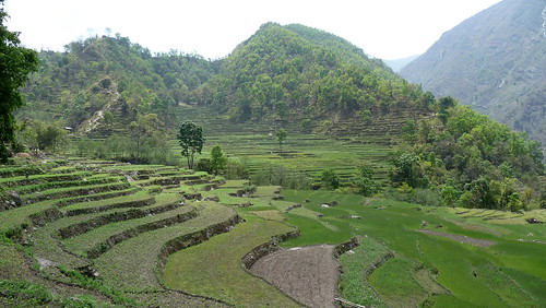
We start the Annapurna Circuit in Besisar, about 5 hours bus ride from Kathmandu. A sub-tropical climate, we are surrounded by banana and other leafy trees, and low, green hills. Terrace farming is everywhere, growing corn, barley and winter wheat. Also stone houses, goats and the ever-present Marsyangdi River, which we will follow all the way up to the Thorong La pass. It is eerily quiet, though, and we meet only one or two other trekkers the entire day of hiking.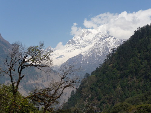
Over the next few days, we fall into a pattern of getting up early, enjoying the relative cool of the first few hours, and stopping occasionally for tea along the way at the numerous tea houses. I realize how much I enjoy Kumar's quiet friendliness - he is quick to point out mountains, plant species and saucy mountain rumors but leaves me to myself for good chunks of the time. I spend a lot of this time being quiet and walking meditatively, which soon has me in pretty blissful state (I think it's hard not to feel this way with so much beauty around you).
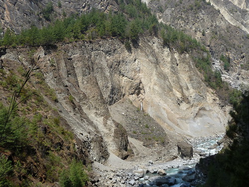
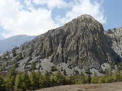
The landscape gradually change from the lush green of the lowlands to more scattered trees and rocky cliffs. A large number of landslides mar the hills along the way, caused by deforestation and also construction of a new road. The road is a bit of a tragedy for the area, as it will continue to the district capital of Manang, which is three-fourths of the way to the Thorung Phedi Pass. It addition to the ugliness it is causing, many people I talk to along the way fear that it will ruin the business of the many tea houses along the lower part of the trek.
Kumar and I occasionally pass directly underneath the road workers, perched on tiny outcroppings above sheer stone dropoffs. They are chisling out big chunks of rock and dropping them below (the trail was littered with them). Kumar would call out for them to pause while we walked underneath but the pounding continued. We instinctively duck our heads, hope for the best, and hurry on our way. Around this time I have my first experience with the apple pie that is famous on this trek. This one looks like a homemade version of a Hostess apple pie, but is delicious.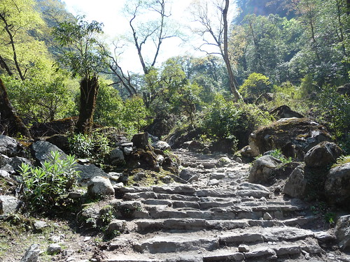
After the barren rockslide area, the land again changes into a temperate forest, with deciduous, pine and rhododendron trees, gooseberries, and orchids. The Annapurna area is home to the world's largest rhododendron forest, as well as a couple of the world's tallest peaks (Annapurna and Dhaulagiri), the world's deepest gorge, and a bunch of other things that Kumar told me and I forgot. 
We also pass many trains of donkeys as they carried supplies up to the villages. The "leader" donkeys of some trains had special harnesses and headdresses indicating their seniority. Kumar tells me that the donkeys are frequently angry at having to carry such heavy loads and had been known to nudge a hapless trekker off a cliff if they weren't careful. They seem nice enough to me but I don't push it.
Trekking business is way down due to the financial crisis, and we continue to be the only guests at our tea houses at night for the first few days. Gradually as we got to some of the larger villages closer to the pass, other trekkers start to show up. It becomes much more social, as you see the same people again and again as they arrive at the next village for the night. I meet great people from America, Germany, the Czech Republic and England, plus some hot Brazilian surfers.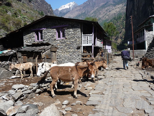

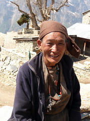
The people in these small mountain villages are friendly, with everyone saying "Namaste" to you as you passed. The villages themselves are a mix of completely traditional living based on farming, alongside more wealthy tea house owners catering to tourists. The kids are open and friendly, grabbing your hand and walking with you for a while, only occasionally asking for a "one school pen, one rupee, one bon-bon" ("Bon-bon"? I wonder who taught them such a bad habit? Hmm, French trekkers?).
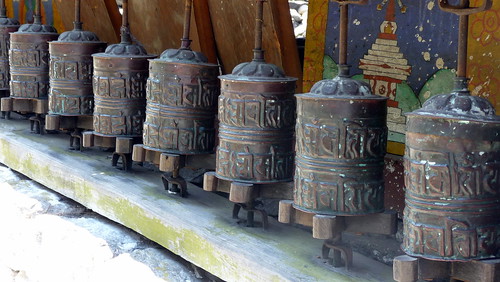
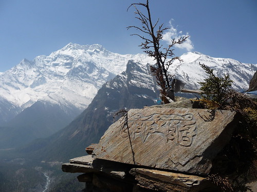
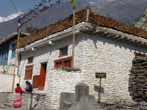
Although Nepal itself is primarily Hindu, Buddhism was the dominent religion in this area, with prayer flags, chortens, monasteries, and prayer stones at nearly every village.
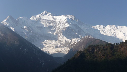
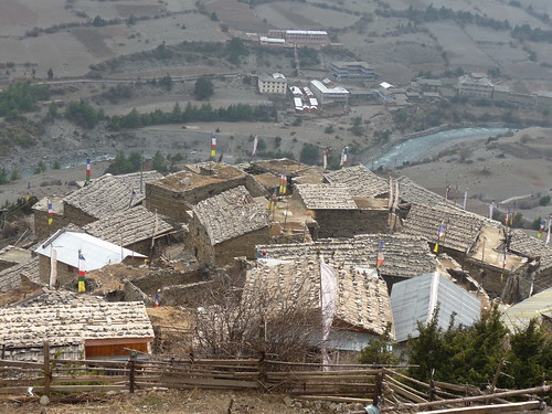
Making our way to the traditional village of Pisang, the landscape again changes to be more deserty as the altitude rose. The pine trees grow shorter and juniper bushes started to dominate. Himalayan mountains (including Annapurna II, III and IV) dominated the skyline. The villages around here are quite old, and built in the traditional style of closely fitted stones with wood roofs. Hundreds of stones lined the top of the roofs, protecting them from the high winds. It starts to get colder and night and guests and porters alike huddle around the wood fire stoves in the dining rooms of the tea houses.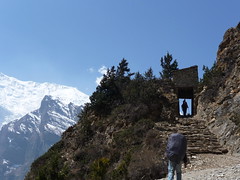
The most beautiful day of the trek is the journey along the Upper Manang Trail connecting Pisang to Manag. This trail starts with a 2 hour steep ascent, and then follows a small path hugging the sheer mountain face for hours of incredible views. 
Manang is the "big city" of this area, with standalone restaurants, internet cafes, bakeries and places to buy that last piece of warm clothing if you forgot something. The internet is as expensive as a costly overseas phone call. It's customary to stop for an extra day in Manang to acclimatize to the altitude, and to attend a free mountain sickness class to put the fear of God into you about climbing the pass.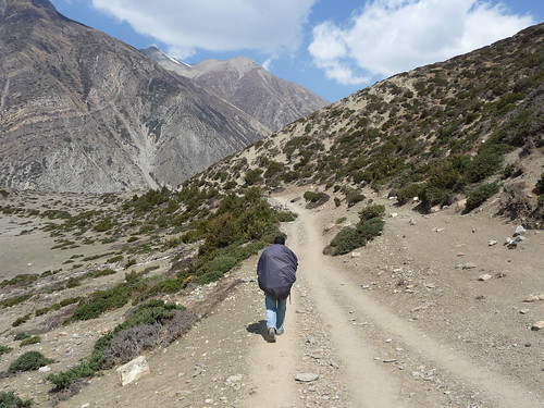
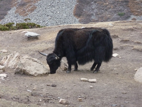
The landscape past Manang becomes even more barren, with only juniper bushes competing with the striking browns and tans of the dry hills. We saw blue sheep today way down below by the river (quite rare) and our first Yak! Yaks are huge, and kinda ornery. Kumar and I were walking back to our hotel after dark and a male yak made a lot of threatening noises toward us like he was going to charge - scary! Much more of a threat than the donkey menace Kumar had described to me. Yak butter, cheese and yogurt are everywhere. Not bad, but not that tasty either.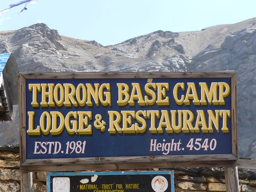
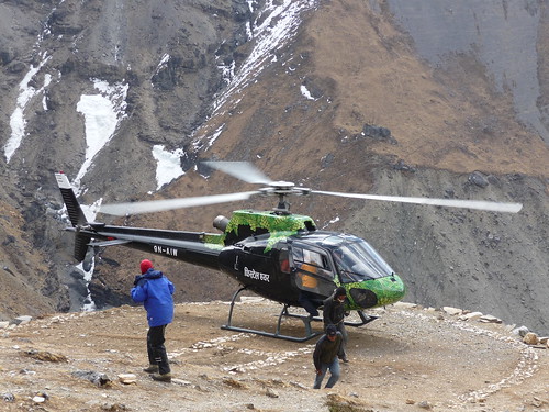
Finally we reach the Thorung La base camp. The land at this point has become almost completely bare, and you can really feel the altitude as you climb. Even the smallest physical activity leaves you panting. Evidence of people falling ill with altitude sickness is frequent - helicopters flying overhead once or twice a day (I watched a German woman being airlifted out of base camp) and donkeys with zonked-out looking trekkers slung across their backs heading down the mountain. Kumar and I complete the hardest climb of the trek, from base camp to high camp. You have to go very slowly to help your body acclimatize as you make the steep ascent.
Thorung High Camp is where most people will base their pass attempt from. Starting up there instead of the lower base camp shaves two hours or so from an already long climbing day. At the camp we huddle in the dining room for hours with all of the other trekkers we've met along the way. There is only one tea house up there, it's a monopoly, and it knows it. Everything is twice as expensive as before. The food's actually pretty good, but the Dal Bhat was evidently tainted (three people who ate it fell ill with food poisening, including myself a day later). At the high altitude, it's difficult to sleep, and I am up much of the night. I have a little bit of an altitude headache, and drink water like mad to stay hydrated.

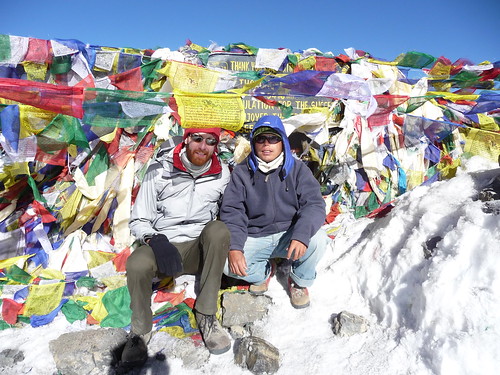
Next morning at 5am we start our ascent. The wind picks up on the pass after about 10am, so you want to be over by about that time. The hike up to the pass is long but kind of spooky and cool in the dark. After an expensive cup of tea and some celebratory pictures at the top, Kumar and I start the long journey down to Muktinath. The descent is actually tougher than going up - an endless steep rocky path, very hard on the feet and knees.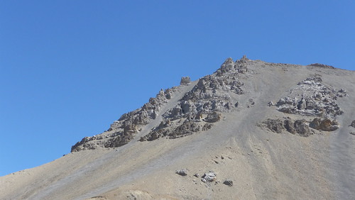
After the pass we find ourselves in the Mustang region of Nepal. Mustang used to be an independent kingdom and has a heavy Tibetan influence. The high mountain desert landscape consists of enormous rock formations and there is almost no vegetation - a very different kind of beauty from the greenery and snowy peaks of the other side.


Muktinath itself is also a change from the villages we have been used to before. An important Hindu pilgramage site, I'm startled by the mass of people, honking trucks and other signs of "civilization". Kumar takes me to an important temple where Hindus from Nepal and India come to wash away their sins, following the example of Lord Krishna (at this point I've been hiking for hours and am just thinking about lunch).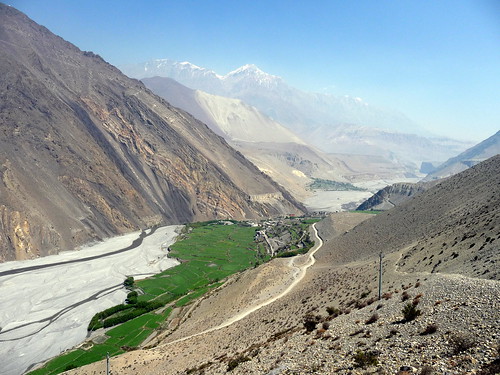
The days after crossing the pass are a bit anti-climatic, and I find myself wondering if I am done with the trek - many people are either taking buses down at this point or flying out from nearby Jomsom. Most of the friends I'd met and been hanging out with disperse, either taking these quicker journeys down the mouuntain or stopping at different villages than I was. My attitude doesn't improve the next day as we slog from Muktinath for seven hours to the cute little village of Marpha, through the dusty wind tunnel of the Kali Gandaki River Valley (note to future trekkers: jeep this part).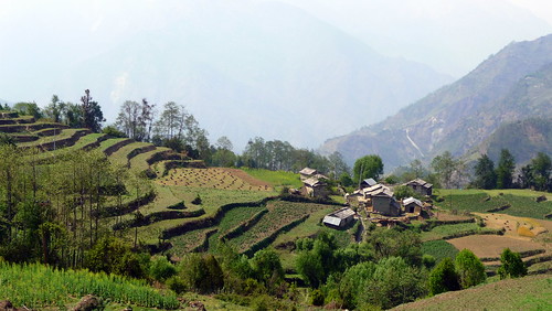

Gradually the surroundings become more lush and less windy as we descend further and vegetation starts to reappear. Pine trees first, followed by rhododendrons, leafy trees, and green terraced fields. I'm happy to have continued - as we arrive in Tatopani by some coincidence many of the trekkers I'd met along the way end up at the same tea house for the night. We have a soak in a *hot* hot springs pool near the river - sweet!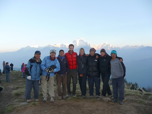
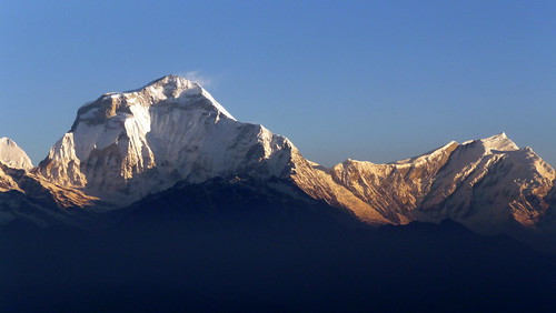
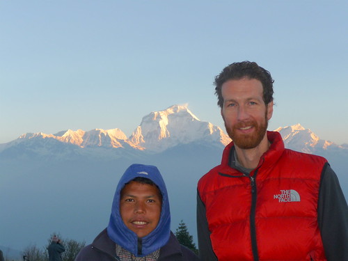
Finally we make it to the last stop on the trek, Gorepani. A solid day of climbing stone steps to get there, Gorepani is perched on a hill between the massive mountains of Dhaulagiri and Annapurna I. One final night hanging out with the trekker gang (staying up drinking rum tea with the Czechs, finally giving in and trying the Mars Bar roll on the menu - not bad), followed by an early morning hike up to the top of Pune Hill for the sunrise. The final views of the Himalayas are the best of the trek. After that, we spend the day descending down stone steps to reach the end point of the trek. 17 days and many miles after starting, Kumar and I arrive at Birethanti and catch a bus to Pokhara.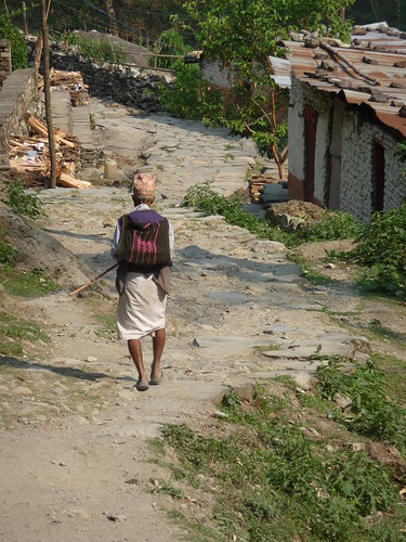
Friday, May 1, 2009
Annapurna Circuit Trek: Dal Bhat, Apple Pie, and deep-fried Mars bars (oh, yeah, and the Himalayas)
Subscribe to:
Posts (Atom)